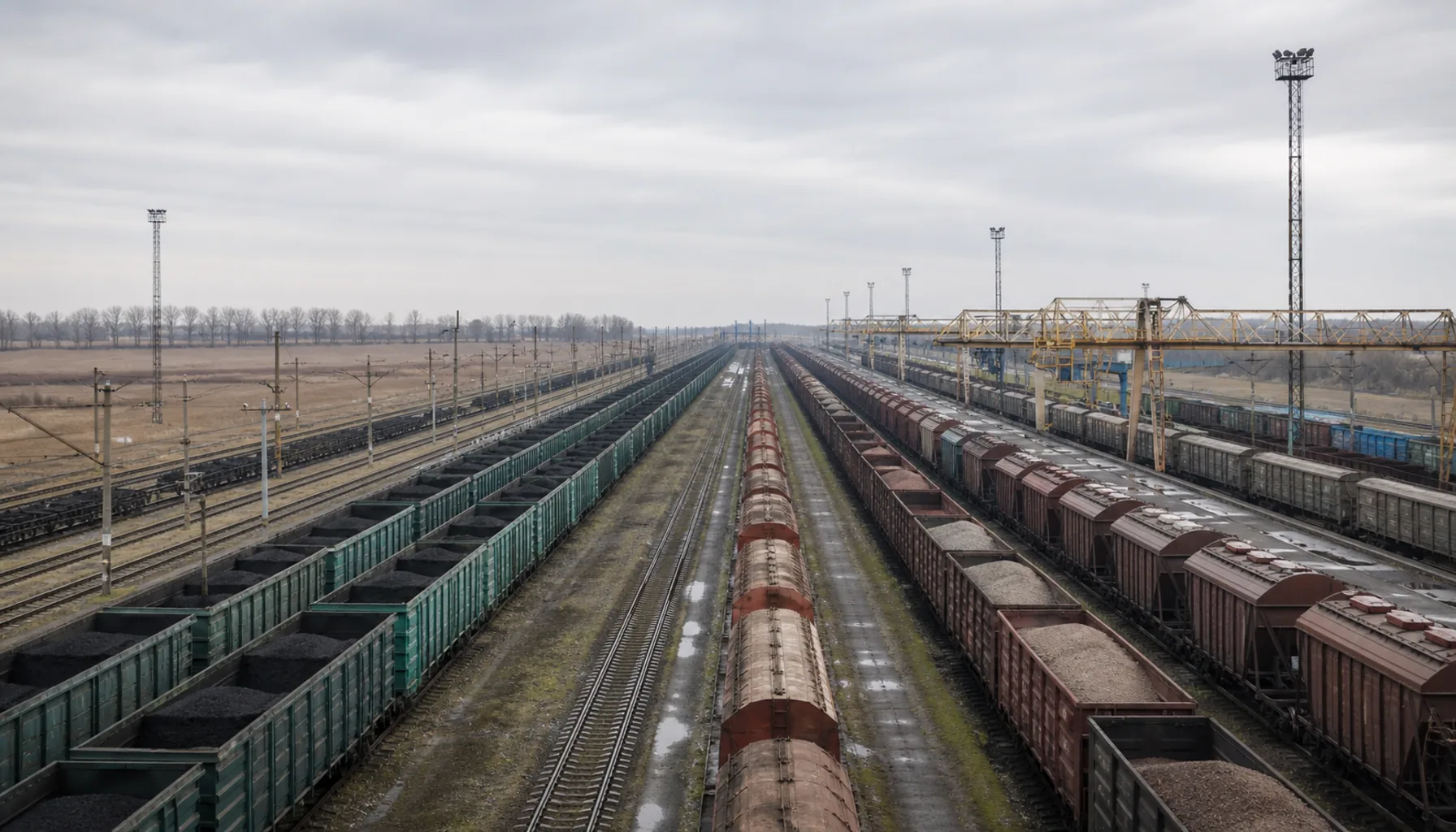
The railway border town where European standard gauge meets the broad gauge of the former Soviet network. The transshipment yard is not in the town: it is the town, and in July 1968 the Soviet and Czechoslovak leaderships met here, three weeks before the invasion.Železničné pohraničné mesto, kde sa európsky normálny rozchod stretáva s koľajou širokou 1520 mm z bývalej sovietskej siete. Prekladisko nie je v meste — ono je tým mestom — a v júli 1968 sa tu stretlo sovietske a československé vedenie, tri týždne pred inváziou.
Broad-gauge and standard-gauge tracks side by side in the transshipment yard at Čierna nad TisouŠirokorozchodné a normálnorozchodné koľaje vedľa seba na prekladisku v Čiernej nad Tisou
Where it standsKde leží
Čierna nad Tisou lies in the flattest, warmest and most south-easterly corner of Slovakia, on the Ukrainian border, with the border station of Chop directly opposite. The land is the East Slovak Plain at its lowest — fields, drainage channels, poplar windbreaks — with a band of railway wider than the town itself cutting across all of it.Čierna nad Tisou leží v najrovnejšom, najteplejšom a najjuhovýchodnejšom cípe Slovenska, na ukrajinskej hranici, priamo oproti pohraničnej stanici Čop. Krajina je tu Východoslovenskou rovinou v jej najnižšej polohe — polia, odvodňovacie kanály, topoľové vetrolamy — a naprieč tým všetkým vedie pás železnice širší než samotné mesto.
The Tisa of the town's name barely touches the country. The great river runs along Slovak territory for only a few kilometres south of here, on the Hungarian border, and that short stretch is the only part of it that is Slovak at all.Tisa z názvu mesta sa krajiny takmer nedotýka. Veľká rieka lemuje slovenské územie len pár kilometrov južne odtiaľto, na maďarskej hranici, a tento krátky úsek je jediný, ktorý je vôbec slovenský.
The storyHistória
There was a village called Čierna here before, and there still is. The town is younger than its railway: after the Second World War the Soviet frontier came to within a few kilometres, the networks on either side of it ran on different gauges, and somebody had to build the place where the load changed trains. The yard was laid out from the late 1940s, the housing followed, and the settlement beside the tracks became a town in its own right in the 1960s.Bola tu predtým dedina Čierna a je tu dodnes. Mesto je mladšie než jeho železnica: po druhej svetovej vojne sa sovietska hranica ocitla pár kilometrov odtiaľto, siete na oboch jej stranách jazdili na rozdielnych rozchodoch a niekto musel postaviť miesto, kde náklad prestúpi z vlaku do vlaku. Prekladisko vznikalo od konca 40. rokov, za ním prišli sídliská a osada pri koľajniciach sa v 60. rokoch stala samostatným mestom.
What that meant in practice was one of the largest transshipment complexes in Europe: kilometres of parallel sidings, tipplers and cranes, ore, coal and grain moving one way and manufactured goods the other, whole trains lifted onto different bogies. At its height it employed thousands: everyone in town either worked there or was related to somebody who did.V praxi to znamenalo jedno z najväčších prekladísk v Európe: kilometre súbežných koľají, výklopníky a žeriavy, ruda, uhlie a obilie jedným smerom a výrobky druhým, celé súpravy prekladané na iné podvozky. V časoch najväčšieho rozmachu tu pracovali tisíce ľudí a v meste človek buď robil na prekladisku, alebo mal niekoho, kto tam robil.
Between 29 July and 1 August 1968 the town held the last talks before the invasion. The Czechoslovak leadership under Alexander Dubček and almost the whole Soviet Politburo met in a railway building beside the yard, chosen precisely because it stood on the frontier: by the accounts of those present the Soviet delegation arrived each morning by special train from Chop and went back across the border at night. The Bratislava declaration followed two days later, and on the night of 20 to 21 August the Warsaw Pact armies crossed. The name of the town has meant that meeting ever since.Od 29. júla do 1. augusta 1968 sa v meste odohrali posledné rokovania pred inváziou. Československé vedenie na čele s Alexandrom Dubčekom a takmer celé sovietske politbyro sa stretli v železničiarskej budove pri prekladisku, na mieste vybranom práve preto, že leží na hranici; podľa svedectiev účastníkov prichádzala sovietska delegácia každé ráno osobitným vlakom z Čopu a na noc sa vracala za hranicu. O dva dni neskôr nasledovala bratislavská deklarácia a v noci z 20. na 21. augusta prekročili hranice vojská Varšavskej zmluvy. Meno mesta odvtedy znamená práve toto stretnutie.
What to seeČo vidieť
Honestly, there is not much to see and the interesting part is off limits: the yard is working railway property behind fences, with no viewing point or museum, and the town itself is post-war blocks and a station. What a traveller does see, from the platform or a road bridge, is the doubling of the tracks — a wider gauge beside a narrower one, and rakes of Soviet-gauge wagons standing longer and higher than anything else on the network.Úprimne, veľa tu na pozeranie nie je a to zaujímavé je neprístupné. Prekladisko je prevádzková železničná plocha za plotmi, bez vyhliadky a bez múzea, a samotné mesto tvoria povojnové bytovky a stanica. Čo cestujúci naozaj uvidí z nástupišťa alebo z cestného nadjazdu, je zdvojenie koľají: širší rozchod vedľa užšieho a súpravy vozňov sovietskeho rozchodu, dlhšie a vyššie než čokoľvek iné na sieti.
The country south and west of the town rewards a car. This is the Medzibodrožie, the flat land between the Latorica, the Bodrog and the Tisa: oxbows, willow carr, wet meadow and low ridges of blown sand, protected in places and among the best bird country in Slovakia in spring and autumn. Kráľovský Chlmec, the market town of that country, is half an hour west.Autom sa vyplatí kraj na juh a západ od mesta. Je to Medzibodrožie, rovina medzi Latoricou, Bodrogom a Tisou: mŕtve ramená, vŕbové porasty, mokré lúky a nízke chrbty naviateho piesku, miestami chránené a na jar i na jeseň patriace k najlepším vtáčím územiam na Slovensku. Kráľovský Chlmec, trhové mesto tohto kraja, je pol hodiny na západ.
Anything to do with crossing the border here should be checked at the time of travel: conditions on Slovakia's eastern frontier have changed repeatedly since 2022 and will change again.Čokoľvek, čo súvisí s prekročením hranice, si overte v čase cesty: pomery na východnej hranici Slovenska sa od roku 2022 opakovane menili a budú sa meniť ďalej.
Work and industryPráca a priemysel
The railway is the industry. Transshipment and wagon handling, with the customs, forwarding and haulage businesses that grew around them, are what the town does. The broad-gauge line that carries iron ore straight to the steelworks near Košice crosses the border further north, at Maťovce; what happens here is the reloading itself, consignment by consignment.Priemyslom je tu železnica. Prekladanie a manipulácia s vozňami spolu s colnými, špedičnými a dopravnými firmami, ktoré okolo nich vyrástli, sú tým, čím sa mesto živí. Širokorozchodná trať, ktorá vezie železnú rudu priamo k oceliarňam pri Košiciach, prechádza hranicu severnejšie, pri Maťovciach; tu ide o samotné prekladanie, zásielku po zásielke.
The volume is not what it was. Trade patterns changed after 1989, again when Slovakia joined the European Union, and again after 2022, when the eastern border became a supply corridor of a different kind. The town's population has fallen a long way from its peak and the district carries some of the highest long-term unemployment in the country; farming on the fertile plain around takes up part of the rest.Objemy už nie sú, čo bývali. Obchodné toky sa zmenili po roku 1989, znova po vstupe Slovenska do Európskej únie a znova po roku 2022, keď sa z východnej hranice stal zásobovací koridor iného druhu. Počet obyvateľov mesta klesol ďaleko pod svoj vrchol a okres má jednu z najvyšších dlhodobých nezamestnaností v krajine. Časť zvyšku pokrýva poľnohospodárstvo na okolitej rovine — na úrodnej a intenzívne obrábanej pôde.
Getting thereAko sa tam dostať
Čierna nad Tisou is the end of the passenger line east from Košice through Trebišov, and the journey takes upwards of two hours; buses serve Kráľovský Chlmec and Trebišov. By road it is a long flat drive across the Medzibodrožie, and the town is a terminus rather than a place on the way anywhere.Čierna nad Tisou je konečnou osobnej trate, ktorá vedie z Košíc na východ cez Trebišov, a cesta trvá vyše dvoch hodín; autobusy premávajú do Kráľovského Chlmca a Trebišova. Autom je to dlhá rovná jazda naprieč Medzibodrožím a mesto je konečnou, nie miestom na ceste niekam ďalej.
Explore Čierna nad TisouObjavujte Čierna nad Tisou
Every part of this place with a page of its own.Každá časť tohto miesta, ktorá má vlastnú stránku.