The Tatras · VillagesTatry · Obce

Liptovská TepličkaLiptovská Teplička

A high village in the Čierny Váh valley whose slopes are still cut into cultivated terraces, with hay barns standing among them and earth cellars dug in below — one of the most complete traditional farming landscapes left in Slovakia.Vysoko položená obec v doline Čierneho Váhu, ktorej svahy sú dodnes rozstupňované do obrábaných terás so senníkmi medzi nimi a zemnými pivnicami pod nimi — jedna z najzachovalejších tradičných poľnohospodárskych krajín, aké na Slovensku zostali.

Where it standsKde leží

Liptovská Teplička lies high in the valley of the Čierny Váh, on the eastern flank of the Low Tatras below Kráľova hoľa, with the Kozie chrbty across the valley to the north. The name points at Liptov, but the road in climbs from the Poprad basin and the village belongs to the Poprad district today.Liptovská Teplička leží vysoko v doline Čierneho Váhu, na východnom boku Nízkych Tatier pod Kráľovou hoľou, s Kozími chrbtami cez dolinu na severe. Názov ukazuje na Liptov, no cesta sem stúpa z Podtatranskej kotliny a obec dnes patrí do okresu Poprad.

It stands at around nine hundred metres, one of the highest positions of any village in the country and right at the limit of where cereals ripen.Stojí v nadmorskej výške okolo deväťsto metrov, čo ju radí medzi najvyššie položené obce v krajine, presne na hranicu, kde ešte obilie dozrieva.

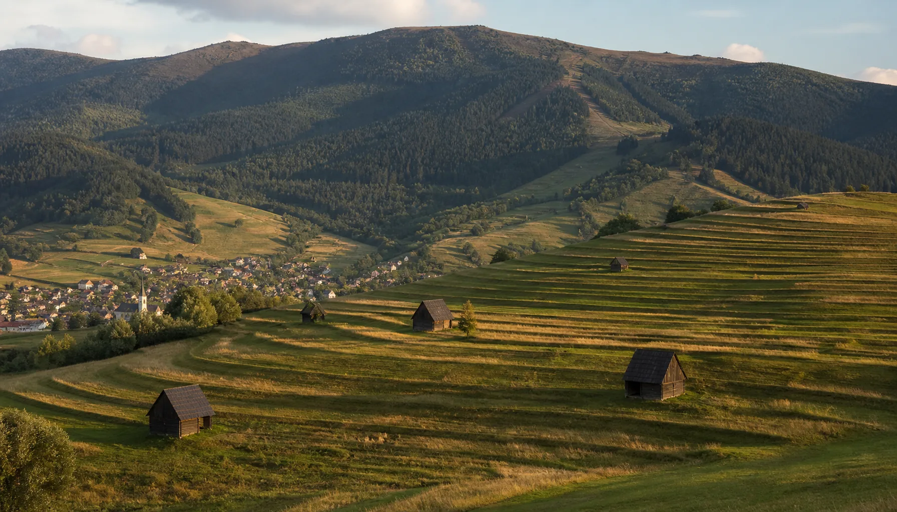
Terraced fields and hay barns on the slopes above Liptovská Teplička
Terraced fields and hay barns on the slopes above Liptovská TepličkaTerasové polia a senníky na svahoch nad Liptovskou Tepličkou

Why it is herePrečo práve tu

The valley was settled late, in the seventeenth century, when the estate pushed grazing and cultivation up into ground nobody had bothered with before. Living came from sheep and cattle, from the forest, and — once it arrived — from the potato, which is the crop that made a permanent village at this height practical.Dolinu osídlili neskoro, v 17. storočí, keď panstvo posunulo pastvu a obrábanie pôdy do miest, o ktoré sa dovtedy nikto neuchádzal. Žilo sa tu z oviec a dobytka, z lesa a — keď sa objavili — zo zemiakov, plodiny, vďaka ktorej bola trvalá obec v tejto výške vôbec možná.

The terraces follow from that. To farm a steep slope you have to hold the soil on it, so generation after generation built the hillside into level steps behind risers of turf and stone, worked by hand and with animals, one narrow strip to a household. The pattern climbed until nearly every slope in sight of the village was under cultivation, with hay barns set out among the fields and earth cellars dug into the ground near the houses to hold the potato crop through the winter.Z toho vyplývajú terasy. Ak chcete obrábať strmý svah, musíte na ňom udržať pôdu, a tak generácia za generáciou vystavali stráň do vodorovných stupňov oddelených trávnatými a kamennými medzami, ručne a s dobytkom, po jednom úzkom páse na gazdovstvo. Polia sa takto šplhali vyššie, kým nebol obrobený takmer každý svah na dohľad od obce, so senníkmi rozostavanými medzi poliami a so zemnými pivnicami vkopanými do zeme pri domoch, aby cez zimu udržali úrodu zemiakov.

Most such landscapes were flattened when field boundaries were swept away for machinery in the second half of the twentieth century. The usual explanation for why this one was not is the simplest: the slopes were too steep for the machines.Väčšinu takýchto krajín zrovnali, keď sa v druhej polovici 20. storočia rušili medze kvôli technike. Bežné vysvetlenie, prečo sa to tejto nestalo, je to najjednoduchšie: svahy boli na stroje príliš strmé.
What you actually seeČo naozaj uvidíte

The view from the roads above the village is the thing to come for: slope after slope stepped into terraces, the lines of them curving with the contour, hay barns spaced across the fields, and clusters of low cellar mounds near the houses. Late summer, when the grass has been cut and the barns are filling, is when it reads most clearly.To, pre čo sa sem chodí, je pohľad z ciest nad obcou: svah za svahom rozstupňovaný do terás, ich čiary sledujúce vrstevnicu, senníky rozostavané po poliach a zhluky nízkych pivničných hrbov pri domoch. Najzreteľnejšie sa to číta koncom leta, keď je tráva pokosená a senníky sa plnia.

In the village itself there are timber houses among the newer building, a church, and a folk tradition that is genuinely still practised — costume, singing and calendar customs that belong to the community rather than to a programme for visitors.V samotnej obci sú medzi novšou zástavbou drevenice, kostol a ľudová tradícia, ktorá sa naozaj stále udržiava — kroj, spev a výročné zvyky, ktoré patria komunite, nie programu pre návštevníkov.

Upstream the Čierny Váh valley holds the country's largest pumped-storage power station, its upper reservoir cut into the ridge high above the water — a startling piece of engineering to meet in an otherwise empty valley.Vyššie proti prúdu je v doline Čierneho Váhu najväčšia prečerpávacia vodná elektráreň v krajine s hornou nádržou vyrezanou do hrebeňa vysoko nad vodou — v inak prázdnej doline prekvapivé stavebné dielo.

Living village, not a museumŽivá obec, nie skanzen

Nothing here is ticketed and nothing is laid on. The terraces are private agricultural land in active use — not a heritage site with a path round it and not a viewpoint with a car park — so look from the public roads and the marked tracks, keep off field tracks in a vehicle, and do not walk through standing grass before it is cut.Nič sa tu neplatí a nič nie je pripravené pre návštevníka. Terasy sú súkromná poľnohospodárska pôda v aktívnom využívaní — nie pamiatkový areál s okružným chodníkom a nie vyhliadka s parkoviskom —, takže sa pozerajte z verejných ciest a značených chodníkov, na poľné cesty nevchádzajte autom a nechoďte cez stojacu trávu, kým nie je pokosená.

The landscape survives because it is still worked, which means two things: it is worth seeing in the working season, roughly May to September, and it will last only as long as the farming does.Krajina sa zachovala preto, že sa v nej stále pracuje, a z toho vyplývajú dve veci: oplatí sa ju vidieť v pracovnej sezóne, zhruba od mája do septembra, a vydrží len dovtedy, dokým vydrží hospodárenie.

Getting thereAko sa tam dostať

There is no railway. Buses run up from Poprad by way of Vikartovce, and by car the road climbs from Vikartovce off the main route between Poprad and Liptovský Mikuláš; beyond the village it carries on into the forest of the Čierny Váh valley.Železnica sem nevedie. Autobusy premávajú z Popradu cez Vikartovce a autom stúpa cesta z Vikartoviec, odbočkou z hlavnej trasy medzi Popradom a Liptovským Mikulášom; za obcou pokračuje do lesov doliny Čierneho Váhu.

← Villages← Obce

WatchPozrite si

Sixteen videos for Liptovská Teplička.Šestnásť videí — Liptovská Teplička.