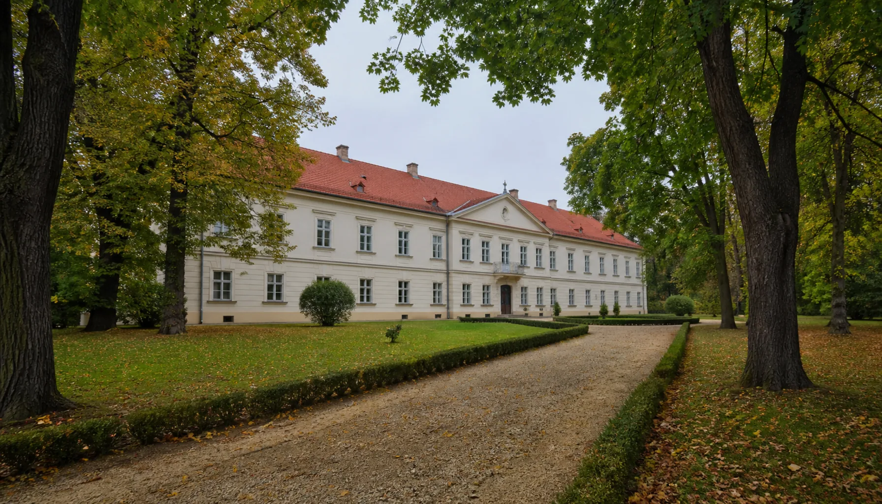
The working capital of the Zemplín, set on the Laborec in the East Slovak Lowland, with a manor house and its museum at the centre, the volcanic ridge of the Vihorlat on the northern skyline and the reservoir Slovaks call the Slovak Sea a few kilometres east.Praktické hlavné mesto Zemplína na Laborci vo Východoslovenskej nížine, s kaštieľom a múzeom v centre, so sopečným chrbtom Vihorlatu na severnom obzore a s vodnou nádržou, ktorej sa hovorí Slovenské more, pár kilometrov na východ.
The Sztaray manor house and its park in the centre of MichalovceKaštieľ Sztárayovcov a jeho park v centre Michaloviec
Where it standsKde leží
Michalovce stands on the Laborec roughly fifty-five kilometres east of Košice, in the flat country of the East Slovak Lowland. The plain runs south and east from the town without a hill in it; to the north the volcanic ridge of the Vihorlat rises abruptly out of the fields and closes the view.Michalovce ležia na Laborci zhruba päťdesiatpäť kilometrov východne od Košíc, v rovine Východoslovenskej nížiny. Na juh a východ sa nížina tiahne bez jediného kopca; na severe sa z polí prudko dvíha sopečný chrbát Vihorlatu a uzatvára výhľad.
It is the largest town of the region after Košice and the practical centre of the Zemplín — the district seat, the hospital town, the market and the place the surrounding villages come to. Zemplínska šírava, the big reservoir under the Vihorlat, is a short drive east.Po Košiciach je najväčším mestom kraja a praktickým centrom Zemplína — okresným sídlom, nemocničným mestom, trhom a miestom, kam chodia okolité obce. Zemplínska šírava, veľká vodná nádrž pod Vihorlatom, je kúsok autom na východ.
The storyHistória
The site has been settled since prehistory and the town is documented from the thirteenth century. For most of its recorded history it belonged to noble estates; the Sztáray family held it from the eighteenth century, and their manor house on the main street is the oldest substantial building in the centre.Miesto je osídlené od praveku a mesto samo je doložené od 13. storočia. Väčšinu svojich zaznamenaných dejín patrilo šľachtickým panstvám; od 18. storočia ho držali Sztárayovci a ich kaštieľ na hlavnej ulici je najstaršou významnou stavbou v centre.
Michalovce grew fast after the Second World War, when the lowland was industrialised and drainage schemes turned marsh into arable land. The housing estates on its edges date from that period, and so does most of the town's present size.Michalovce rýchlo rástli po druhej svetovej vojne, keď sa nížina industrializovala a odvodňovacie projekty premenili močiare na ornú pôdu. Z tých čias pochádzajú sídliská na okrajoch mesta aj väčšina jeho dnešnej veľkosti.
The single change that mattered most to the landscape was the building of Zemplínska šírava in the 1960s. The reservoir was made to hold floodwater and to irrigate the plain; recreation came afterwards, and with it the strip of holiday settlements along the northern shore.Krajinu najviac zmenila stavba Zemplínskej šíravy v 60. rokoch. Nádrž vznikla, aby zadržiavala povodňovú vodu a zavlažovala rovinu; rekreácia prišla až potom a s ňou aj pás chatových osád pozdĺž severného brehu.
What to seeČo vidieť
The Sztáray manor house holds the Zemplín Museum, the main collection for the region — county history, archaeology from the lowland sites, and period interiors. The park around it is the green centre of the town.V kaštieli Sztárayovcov sídli Zemplínske múzeum, hlavná zbierka regiónu — dejiny stolice, archeológia z nížinných lokalít a dobové interiéry. Park okolo neho je zeleným centrom mesta.
Michalovce is one of the places where the Byzantine-rite churches are most visible: Greek Catholic and Orthodox parishes stand alongside the Roman Catholic ones, and the town is one of the centres of eastern-rite church life in Slovakia.Michalovce sú jedným z miest, kde je cirkev byzantského obradu najviditeľnejšia: gréckokatolícke a pravoslávne farnosti stoja vedľa rímskokatolíckych a mesto patrí k centrám východného kresťanstva na Slovensku.
Most of what draws visitors is just outside. Zemplínska šírava has beaches, campsites and the small lake at Vinné above it; the ruin of Vinné castle stands on a vineyard hill near the northern shore; and the Vihorlat behind it holds beech forest, marked trails and the volcanic lake of Morské oko.Väčšina toho, čo priťahuje návštevníkov, je hneď za mestom. Zemplínska šírava má pláže, kempy a nad sebou malé Vinianske jazero; na vinohradníckom kopci pri severnom brehu stojí zrúcanina Vinianskeho hradu a Vihorlat za ňou ukrýva bukové lesy, značené chodníky a sopečné jazero Morské oko.
Work and industryPráca a priemysel
Agriculture and food processing underpin the local economy — this is some of the most productive farmland in Slovakia — and manufacturing has been added to them: engineering, building materials, and a large plant making electric motors and pumps for household appliances. The hospital, the schools and the district offices employ a large share of the town.Základom miestneho hospodárstva je poľnohospodárstvo a potravinárstvo — ide o jednu z najúrodnejších oblastí Slovenska — a k nim pribudla výroba: strojárstvo, stavebné materiály a veľký závod na elektromotory a čerpadlá pre domáce spotrebiče. Veľkú časť mesta zamestnávajú nemocnica, školy a okresné úrady.
Summer tourism on the Šírava is a real seasonal industry and the town gains from it, but the lake's water quality and its resorts have had uneven decades. Check the state of a particular resort before you plan around it.Letný cestovný ruch na Šírave je skutočným sezónnym odvetvím a mesto z neho ťaží, no kvalita vody aj jednotlivé strediská mali za sebou nerovnaké desaťročia. Stav konkrétneho strediska si pred plánovaním overte.
Getting thereAko sa tam dostať
Trains run from Košice to Michalovce and on to Humenné, and buses serve the town from Košice, Trebišov and Sobrance. By road it is on the main route east from Košice towards the Ukrainian border.Vlaky idú z Košíc do Michaloviec a ďalej do Humenného, autobusy premávajú z Košíc, Trebišova aj zo Sobraniec. Cestne leží mesto na hlavnom ťahu z Košíc na východ smerom k ukrajinskej hranici.
Explore MichalovceObjavujte Michalovce
Every part of this place with a page of its own.Každá časť tohto miesta, ktorá má vlastnú stránku.