Slovakia · the Low Tatras ridgeSlovensko · hrebeň Nízkych Tatier
Ďumbier and ChopokĎumbier a Chopok
Ďumbier, 2,043 m, is the high point of the Low Tatras and the highest Slovak mountain outside the Tatras; Chopok, 2,024 m, has a cable car almost to the top. The bare ridge between the two is the best-known high traverse in the country — and the easiest way in Slovakia to end up at two thousand metres without having walked there.Ďumbier (2 043 m) je najvyšší bod Nízkych Tatier a najvyšší slovenský vrch mimo Tatier; na Chopok (2 024 m) vyvezie lanovka takmer až na vrchol. Holý hrebeň medzi nimi je najznámejšia hrebeňovka v krajine — a zároveň najľahší spôsob, ako sa na Slovensku ocitnúť vo výške dvetisíc metrov bez toho, aby ste tam vyšli pešo.
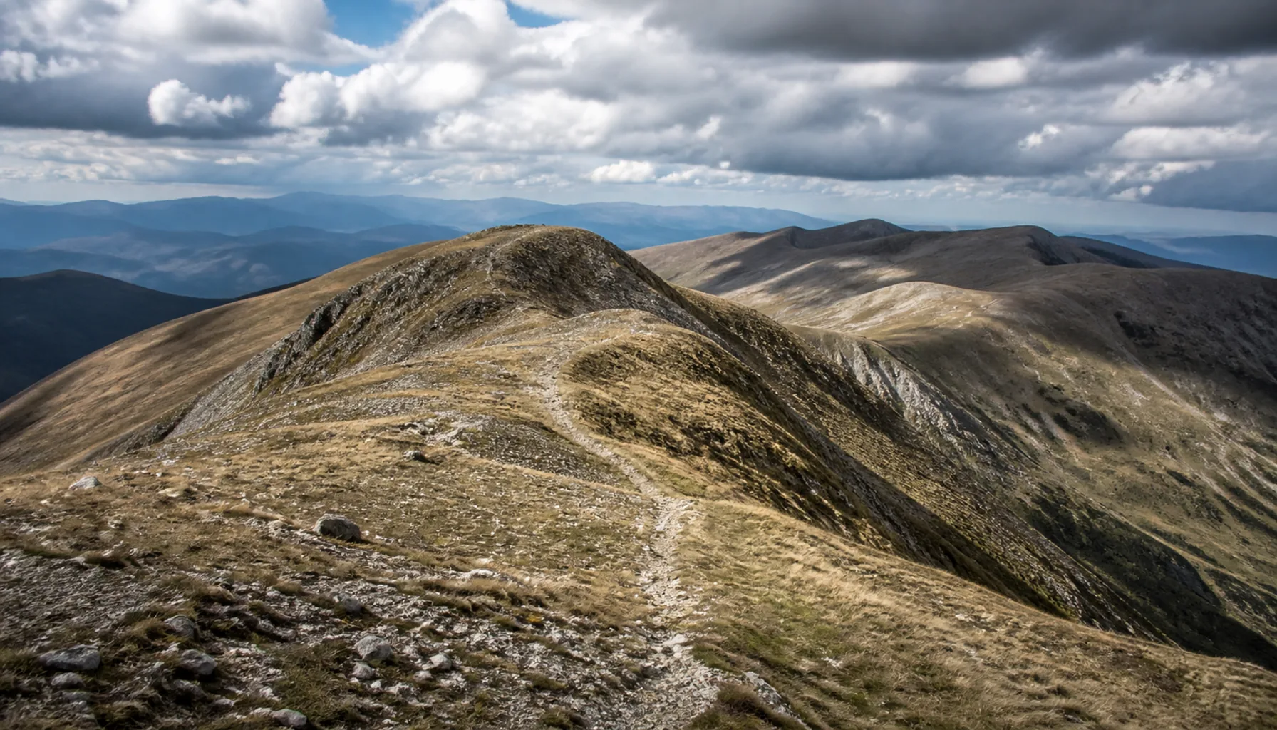
The open ridge between Chopok and Ďumbier, with nothing to break the wind.Otvorený hrebeň medzi Chopkom a Ďumbierom — vietor tu nič nezastaví.
Two summits and the ridge between themDva vrcholy a hrebeň medzi nimi
Ďumbier is a rock summit, not a grassy dome: the last stretch is a scramble over blocks — you will not get up it with your hands in your pockets — and from the top the ground falls away into the Liptov basin with the whole High Tatra skyline beyond it. Chopok, at the other end of the crest, is far gentler: a broad stony top with nothing to climb. Published heights for Ďumbier differ by a few metres depending on the survey — you will see 2,043 m and 2,046 m in print — which changes nothing about the walk.Ďumbier nie je trávnatá kupola, ale skalný vrchol: posledný úsek vedie lezením po balvanoch — bez rúk sa hore nedostanete — a z vrcholu vidno hlboko dolu do Liptovskej kotliny a za ňou celú panorámu Vysokých Tatier. Chopok na druhom konci hrebeňa je oveľa miernejší: široké kamenisté temeno bez akéhokoľvek lezenia. Údaje o výške Ďumbiera sa podľa merania líšia o niekoľko metrov, v literatúre nájdete 2 043 aj 2 046 m. Na samotnej túre to nemení nič.
Between them the red waymarks run some five kilometres along a bare, stony crest above the last of the dwarf pine — around two hours one way, so four there and back before you count a single stop. The ground drops steeply into the Demänovská valley on the north side and towards Bystrá on the south. There is shade nowhere on it, and no shelter on the crest itself: the huts stand at the two ends.Medzi nimi vedie červená značka asi päť kilometrov po holom kamenistom hrebeni nad poslednou kosodrevinou — zhruba dve hodiny jedným smerom, teda štyri tam aj späť, a to bez jedinej zastávky. Terén padá strmo na severnú stranu do Demänovskej doliny a na južnú k Bystrej. Tieň tu nie je nikde a na samotnom hrebeni ani úkryt: chaty stoja až na jeho koncoch.
What the cable car changesČo mení lanovka
Jasná, on Chopok's northern slopes, is the biggest ski resort in Slovakia, and its lifts carry walkers in summer as well as skiers in winter — the summit is a few minutes above the top station. A second line climbs the southern side from Srdiečko. Which lifts are turning, and how late in the day, changes with the season and the weather, so check with the resort rather than building a plan around a last car down that may not be there.Jasná na severných svahoch Chopku je najväčšie lyžiarske stredisko na Slovensku a jej lanovky vozia v lete turistov tak ako v zime lyžiarov — z hornej stanice ostáva na vrchol pár minút. Druhá lanovka stúpa z južnej strany od Srdiečka. Ktoré lanovky práve premávajú a dokedy, sa mení podľa sezóny aj počasia, preto si to overte priamo v stredisku a nestavajte plán na poslednú jazdu dolu, ktorá tam nemusí byť.
That changes who is up there. A two-thousand-metre summit becomes an afternoon out rather than a mountain day, and on a fine Saturday you will meet people in trainers and no jacket an hour's walk from the nearest roof. The walking itself is not hard. The altitude, the wind and the distance from help are real all the same.Mení to, kto sa na hrebeni ocitne. Z dvetisícového vrcholu je zrazu popoludňajší výlet namiesto celodennej horskej túry a za pekného víkendu stretnete ľudí v teniskách a bez bundy hodinu chôdze od najbližšej strechy. Samotná chôdza tu ťažká nie je. Nadmorská výška, vietor a vzdialenosť od pomoci sú však celkom skutočné.
The lift is also the first thing the weather takes away. Chopok is one of the windiest places in the country, and the cable cars stop when the wind gets up — sometimes while you are out on the ridge. Anyone who rides up should know the walking way down and be prepared to use it.Lanovka je zároveň prvá vec, ktorú počasie vezme. Chopok patrí k najveternejším miestam v krajine a keď sa vietor oprie, lanovky zastavia — občas práve vtedy, keď ste na hrebeni. Kto sa dá vyviezť, mal by poznať cestu dolu pešo a rátať s tým, že ju použije.
The long way: the Štefánikova magistrálaDlhá cesta: Štefánikova magistrála
The Chopok–Ďumbier crossing is a fragment of something much longer. The red trail along the main ridge — the old Štefánikova magistrála, which along this stretch carries the waymarks of the Cesta hrdinov SNP — runs the length of the range, Donovaly in the west to Kráľova hoľa in the east, cut in two by the road pass at Čertovica. Walking the whole of it is a multi-day undertaking; Čertovica is the one place a road crosses the ridge, and so the obvious way on or off it.Prechod Chopok – Ďumbier je len zlomkom čohosi oveľa dlhšieho. Červená značka po hlavnom hrebeni — stará Štefánikova magistrála, po ktorej v tomto úseku vedie aj Cesta hrdinov SNP — prechádza celým pohorím od Donovál na západe po Kráľovu hoľu na východe a pretína ju cestné sedlo Čertovica. Prejsť ho celý je viacdňová záležitosť; Čertovica je jediné miesto, kde hrebeň križuje cesta, a teda aj najprirodzenejší nástup naň i únik z neho.
Huts up there are few and far apart, which is exactly what makes them matter. Chata M. R. Štefánika stands below Ďumbier on the southern side, a short marked descent off the crest; Kamenná chata pod Chopkom sits at the other end of the traverse, just under Chopok itself. They are somewhere to break a long day, and more often somewhere to get out of the weather.Chát je na tomto hrebeni málo a sú ďaleko od seba — a práve preto sú také dôležité. Chata M. R. Štefánika stojí pod Ďumbierom na južnej strane, z hrebeňa k nej vedie krátky značený zostup; Kamenná chata pod Chopkom je na druhom konci prechodu, tesne pod samotným Chopkom. Dá sa v nich rozdeliť dlhý deň a ešte častejšie sa v nich ľudia schovajú pred počasím.
Nothing to hide behindNie je sa kde skryť
The crest is above the treeline for its whole length and it funnels wind. Cloud closes in within minutes and a path over flat stony ground is then hard to follow; summer storms build in the afternoon, and there is nowhere lower to duck to — the ways off descend a thousand metres and take hours. Carry water for the whole crest, because there is none on it.Hrebeň je po celej dĺžke nad hornou hranicou lesa a fúka na ňom ako v tuneli. Oblačnosť sa zavrie za pár minút a chodník po plochom kamenistom teréne sa potom hľadá ťažko; letné búrky sa tvoria popoludní a niet kam ustúpiť nižšie — zostupy do dolín majú tisíc metrov prevýšenia a trvajú hodiny. Vodu si vezmite na celý hrebeň, cestou žiadna nie je.
In winter this is a serious mountain: snow lies late, cornices build along the crest, and avalanche conditions are normal rather than exceptional — while the lift still puts people at two thousand metres in weather that would have turned back anyone walking up. Check the forecast and the avalanche bulletin before you go; waymarks, seasons and mountain rescue are covered separately.V zime je to vážna hora: sneh tu leží dlho, na hrebeni sa tvoria snehové previsy a lavínové podmienky sú bežné, nie výnimočné — a lanovka pritom vyvezie človeka do výšky dvetisíc metrov aj za počasia, ktoré by každého stúpajúceho pešo dávno otočilo. Pred cestou si pozrite predpoveď aj lavínovú situáciu; o značkách, sezónach a horskej záchrane píšeme osobitne.
And note what does not happen here: nothing closes for the winter. In the High Tatras the trails above the huts are shut every year from 1 November to 15 June; the Low Tatras ridge carries no such blanket closure, so the mountain is legally open in exactly the conditions that make it dangerous, and the decision is entirely yours. Individual trails in the national park can still be closed seasonally or after storm damage — read the boards where the path leaves the valley.A všimnite si, čo sa tu naopak nedeje: na zimu sa nič nezatvára. Vo Vysokých Tatrách sú chodníky nad chatami každoročne zatvorené od 1. novembra do 15. júna; hrebeň Nízkych Tatier plošnú uzáveru nemá, takže hora je otvorená presne vtedy, keď je najnebezpečnejšia, a rozhodnutie je len na vás. Jednotlivé chodníky v národnom parku môžu byť aj tak sezónne alebo po veternej kalamite uzavreté — prečítajte si tabule tam, kde chodník opúšťa dolinu.
Doing it properlyAko na to
The standard day rides the lift from Jasná to Chopok, walks the ridge to Ďumbier and comes back the same way — the only real decision being whether to catch the last car down or walk off. From the south you start at Mýto pod Ďumbierom and go up the Bystrá valley: quieter, and a good deal longer.Bežný deň vyzerá takto: lanovkou z Jasnej na Chopok, po hrebeni na Ďumbier a tou istou cestou späť; jediné skutočné rozhodnutie je, či stihnúť poslednú lanovku dolu, alebo zísť pešo. Z juhu sa vychádza z Mýta pod Ďumbierom Bystrou dolinou — býva tam ticho a je to podstatne dlhšie.
Walking up is the better mountain if you have the day for it: the path out of the Demänovská valley — the same valley that holds the Demänovská caves — climbs through forest and dwarf pine and earns the ridge honestly. Wind and rain layers, water for the whole crest, a map you can still use with the cloud down, and boots rather than trainers: stony ground turns ankles.Ak máte na to celý deň, výstup pešo je lepšia hora: chodník z Demänovskej doliny — z tej istej, v ktorej sú demänovské jaskyne — stúpa lesom a kosodrevinou a hrebeň si tak človek poctivo odpracuje. Vetrovka a nepremokavá vrstva, voda na celý hrebeň, mapa, ktorú viete použiť aj v hmle, a namiesto tenisiek poriadna obuv: na kamenistom teréne si ľahko podvrtnete členok.
Nothing on this route asks for climbing skill or a licensed mountain guide — unlike Gerlachovský štít, where one is required by law. What it asks for is the weather taken seriously, an honest look at the clock, and the willingness to turn round somewhere on the ridge rather than at the summit.Na tejto trase netreba lezecké zručnosti ani horského vodcu — na rozdiel od Gerlachovského štítu, kde ho vyžaduje zákon. Treba brať vážne počasie, poctivo si strážiť čas a byť ochotný otočiť sa niekde na hrebeni, nie až pod vrcholom.