Banská Bystrica region · TownsBanskobystrický kraj · Mestá
BreznoBrezno
The market town of the upper Hron, with a long square between the Low Tatras and the Ore Mountains, a steel-tube works a few kilometres down the valley and a working forest railway in the woods behind it.Trhové mesto horného Pohronia s dlhým námestím medzi Nízkymi Tatrami a Rudohorím, s rúrovňou pár kilometrov dolu údolím a s činnou lesnou železnicou v lesoch za ním.
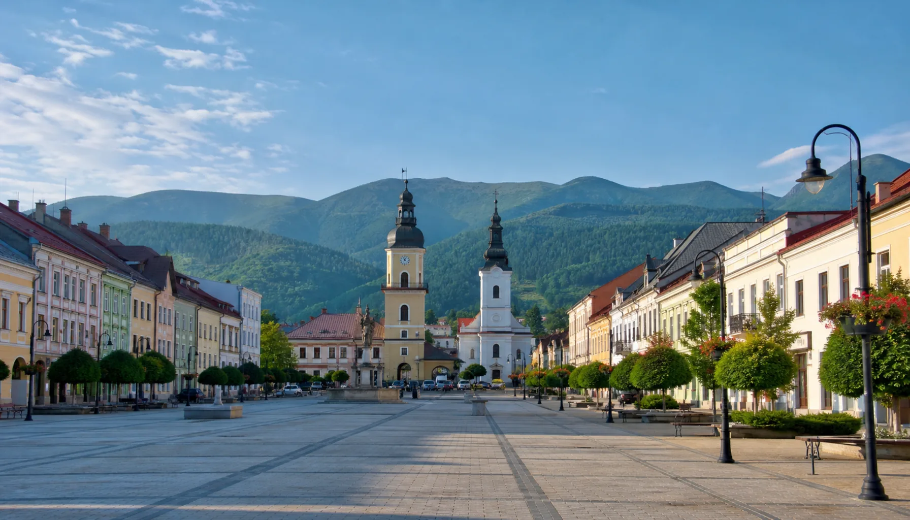
Brezno's long main square, with the Low Tatras rising beyond the rooftopsDlhé breznianske námestie, nad strechami sa dvíhajú Nízke Tatry
Where it standsKde leží
Brezno stands in the upper Hron valley — Horehronie — about forty kilometres east of Banská Bystrica, with the Low Tatras rising steeply to the north and the Veporské hills of the Slovak Ore Mountains closing the valley to the south. The valley floor is narrow, the villages string out along it, and the mountains are visible from every street.Brezno leží v hornom Pohroní — na Horehroní — asi štyridsať kilometrov východne od Banskej Bystrice; na severe sa strmo dvíhajú Nízke Tatry, na juhu údolie uzatvárajú Veporské vrchy Slovenského rudohoria. Dno doliny je úzke, obce sa po ňom navliekajú v rade a hory vidno z každej ulice.
It is the natural base for the southern side of the Low Tatras, which is the quieter side: fewer lifts, more forest, and the main ridge reached on foot from the valleys rather than from a cable car.Je prirodzeným východiskom na južnú stranu Nízkych Tatier — tú tichšiu: menej vlekov, viac lesa a na hlavný hrebeň sa vystupuje pešo z dolín, nie lanovkou.
The storyHistória
Brezno was a royal town with market rights from the Middle Ages, and for centuries it lived on what a mountain valley produces: cattle and sheep from the high pastures, timber floated down the Hron on rafts, iron and copper worked in small hammer mills in the side valleys. The long square, wide enough for a fair and closed at one end by the church and the town hall, is the shape that trade left behind.Brezno bolo kráľovským mestom s trhovým právom už od stredoveku a stáročia žilo z toho, čo horská dolina dáva: z dobytka a oviec z horských pasienkov, z dreva plaveného po Hrone na pltiach a zo železa a medi spracúvaných v malých hámroch v bočných dolinách. Dlhé námestie, dosť široké na jarmok a na jednom konci uzavreté kostolom a radnicou, je tvarom, ktorý po tomto obchode zostal.
Industry arrived in the nineteenth century a few kilometres downstream at Podbrezová, where an ironworks was built to use local ore and charcoal. It outlived the ore, converted to making steel tubes, and is still working — one of the few Slovak plants with a continuous line back to the age of charcoal iron.Priemysel prišiel v devätnástom storočí pár kilometrov po prúde, do Podbrezovej, kde postavili železiareň na miestnu rudu a drevené uhlie. Prežila rudu, prešla na výrobu oceľových rúr a pracuje dodnes — jeden z mála slovenských závodov s neprerušenou líniou až do čias uhliarskeho železa.
The valleys above the town were logged industrially from the same period, and the narrow-gauge railways built to bring the timber down are the reason one of them still runs.Doliny nad mestom sa od tých čias ťažili priemyselne a úzkokoľajky postavené na zvoz dreva sú dôvodom, prečo jedna z nich premáva dodnes.
What to seeČo vidieť
The square is the town: a long open space with the town hall and the parish church at its head and burghers' and craftsmen's houses down both sides. It is a working square rather than a museum one, and the market still happens on it.Mesto je námestie: dlhý otvorený priestor s radnicou a farským kostolom v čele a s meštianskymi a remeselníckymi domami po oboch stranách. Je to námestie pracovné, nie múzejné — trh sa na ňom koná dodnes.
The Čiernohronská forest railway at Čierny Balog, in the valley south of Brezno, is the best-known thing in the district: a narrow-gauge line built to carry timber, saved from scrapping by volunteers, and now running steam and diesel trains through the woods to an open-air forestry museum at Vydrovo. It is a genuine working heritage railway rather than a fairground ride.Čiernohronská železnica v Čiernom Balogu, v doline južne od Brezna, je najznámejšou vecou v okrese: úzkokoľajka postavená na zvoz dreva, zachránená pred zošrotovaním dobrovoľníkmi, ktorá dnes vozí parné aj motorové vlaky lesom k lesníckemu skanzenu vo Vydrovskej doline. Je to skutočná činná historická železnica, nie púťová atrakcia.
North of the town the road climbs to Mýto pod Ďumbierom and the southern approaches to Chopok and Ďumbier, and the Bystrianska cave lies at the foot of the same slope. East of Brezno the Hron valley narrows towards Muráň and Gemer.Severne od mesta stúpa cesta k Mýtu pod Ďumbierom a k južným prístupom na Chopok a Ďumbier a na úpätí toho istého svahu leží Bystrianska jaskyňa. Východne od Brezna sa dolina Hrona zužuje smerom na Muráň a Gemer.
Work and industryPráca a priemysel
The steel-tube works at Podbrezová is the district's largest employer and has been for generations. Around it are forestry and sawmilling, a dairy processing milk from the Horehronie farms, and the winter and summer tourism the Low Tatras bring.Rúrovňa v Podbrezovej je najväčším zamestnávateľom okresu a je ním už po generácie. Okolo nej stojí lesníctvo a píly, mliekareň spracúvajúca mlieko z horehronských fariem a zimný i letný cestovný ruch, ktorý prinášajú Nízke Tatry.
Sheep are still kept on the high pastures, and bryndza and sheep cheeses are sold at the roadside all summer.Na horských pasienkoch sa stále chovajú ovce a bryndza i ovčie syry sa celé leto predávajú pri ceste.
Getting thereAko sa tam dostať
The railway from Banská Bystrica runs up the Hron through Brezno and on east towards Červená Skala; the main road east does the same, and a mountain road crosses the Čertovica pass north into Liptov. Buses connect the town with Banská Bystrica and the valley villages.Železnica z Banskej Bystrice ide hore Pohroním cez Brezno a ďalej na východ smerom na Červenú Skalu; rovnako vedie hlavná cesta na východ a horská cesta prekonáva sedlo Čertovica na sever do Liptova. Autobusy spájajú mesto s Banskou Bystricou a s obcami v doline.
Explore BreznoObjavujte Brezno
Every part of this place with a page of its own.Každá časť tohto miesta, ktorá má vlastnú stránku.