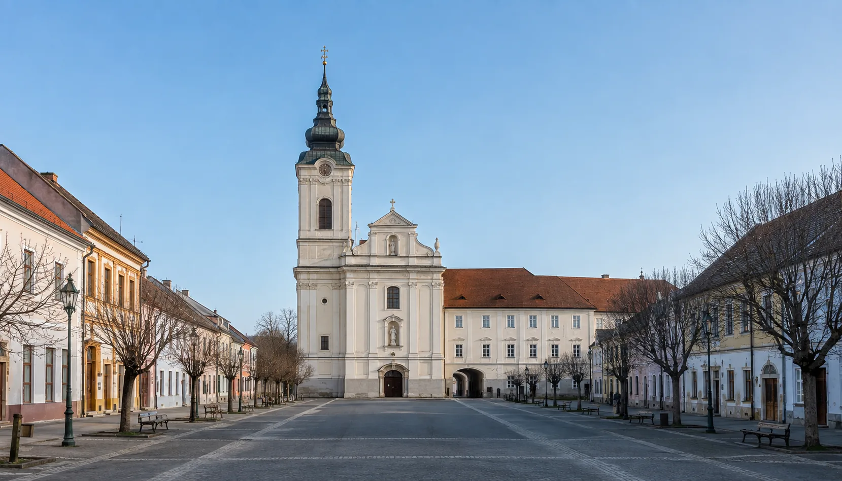
The old seat of Hont county, on the Ipeľ where the river becomes the Hungarian border — a bilingual market town with a Premonstratensian church at its centre and one of the busiest road crossings on the southern frontier.Staré sídlo Hontianskej stolice na Ipli, kde sa rieka stáva maďarskou hranicou — dvojjazyčné trhové mesto s premonštrátskym kostolom v strede a s jedným z najrušnejších cestných priechodov na južnej hranici.
The former Premonstratensian provostry church at the head of the main square in ŠahyBývalý premonštrátsky prepoštský kostol na čele hlavného námestia v Šahách
Where it standsKde leží
Šahy stand on the left bank of the Ipeľ, at the point where the river stops being a river of the Hont country and becomes the border with Hungary. The Ipeľ basin opens away to the south and east; northward the ground climbs onto the Krupina plateau and, beyond it, into the mining hills around Banská Štiavnica.Šahy ležia na ľavom brehu Ipľa, v mieste, kde rieka prestáva byť riekou Hontu a stáva sa hranicou s Maďarskom. Ipeľská kotlina sa odtiaľ otvára na juh a východ, na sever terén stúpa na Krupinskú planinu a za ňou do banských kopcov okolo Banskej Štiavnice.
The town is bilingual in the fullest sense: most of its people speak Hungarian at home, notices and street names come in both languages, and the Hungarian name Ipolyság is in everyday use. This is the southern edge of the historic Hont region and the last Slovak town on the road towards Budapest.Mesto je dvojjazyčné v plnom zmysle slova: väčšina obyvateľov hovorí doma po maďarsky, oznamy aj názvy ulíc sú v oboch jazykoch a maďarské meno Ipolyság sa bežne používa. Je to južný okraj historického Hontu a posledné slovenské mesto na ceste smerom na Budapešť.
The storyHistória
A Premonstratensian provostry was founded here in the thirteenth century by a lord of the Hunt-Poznan kindred, and the town takes both its name and its beginning from it. The house held the market rights and served as a place of authentication, drawing up and keeping the charters of the surrounding country — which is why a settlement of this size existed at all on an otherwise thinly held stretch of the Ipeľ.Premonštrátsku prepozitúru tu v 13. storočí založil pán z rodu Hunt-Poznanovcov a mesto od nej odvodzuje svoje meno aj svoj začiatok. Kláštor držal trhové práva a pôsobil ako hodnoverné miesto, ktoré vyhotovovalo a strážilo listiny okolitého kraja — a práve preto na inak riedko osídlenom úseku Ipľa vôbec vyrástlo sídlo tejto veľkosti.
The Ottoman frontier ran through this country for a century and a half, and Šahy changed hands and burned more than once; the monastery was dissolved, refounded and rebuilt. In the nineteenth century the town became the administrative seat of Hont county, and the county hall raised for that purpose is still one of the largest buildings in the centre.Osmanská hranica prechádzala týmto krajom poldruha storočia a Šahy viackrát zmenili pána i vyhoreli; kláštor zrušili, obnovili a prestavali. V 19. storočí sa mesto stalo sídlom Hontianskej stolice a župný dom, postavený práve na tento účel, je dodnes jednou z najväčších budov v centre.
The border drawn in 1920 cut the town off from half its natural hinterland, which lay on the far bank. Šahy were attached to Hungary again between 1938 and 1945 and then handed back, and the Ipeľ stayed a hard frontier for most of the century that followed — a state of affairs that only eased once both countries joined the open-border area.Hranica z roku 1920 odrezala mesto od polovice jeho prirodzeného zázemia, ktoré ostalo na druhom brehu. V rokoch 1938 – 1945 boli Šahy znovu pripojené k Maďarsku a potom vrátené a Ipeľ zostal po väčšinu nasledujúceho storočia tvrdou hranicou — uvoľnilo sa to až po vstupe oboch krajín do priestoru bez hraničných kontrol.
What to seeČo vidieť
The former provostry church, Baroque in its present form and medieval underneath, stands at the head of the main square with the monastery range beside it. The square is long and open, lined with low nineteenth-century houses, and the town's Hont museum and gallery holds county history, archaeology and a picture collection built around painters who worked in the region.Bývalý prepoštský kostol, dnes barokový a pod tým stredoveký, stojí na čele hlavného námestia spolu s kláštorným krídlom. Námestie je dlhé a otvorené, lemované nízkymi domami z 19. storočia, a mestské hontianske múzeum a galéria uchováva dejiny stolice, archeológiu a obrazovú zbierku postavenú okolo maliarov, ktorí v kraji pôsobili.
The Ipeľ itself repays an hour. Below the town the river is quiet water with willows and old meanders, and the bridge into Hungary is a plain working crossing rather than a monument. Walking or cycling over and back is the simplest way to grasp what the border did to this place.Za hodinu stojí aj samotný Ipeľ. Pod mestom je to tichá voda s vŕbami a starými meandrami a most do Maďarska je obyčajným pracovným priechodom, nie pamiatkou. Prejsť sa alebo prebicyklovať na druhú stranu a späť je najjednoduchší spôsob, ako pochopiť, čo hranica s týmto miestom urobila.
Dudince, the small spa on the road north towards Krupina, is close enough for an afternoon, and that road carries on into the Štiavnica hills. In the other direction the Ipeľ valley runs east through a string of villages that see very few visitors.Dudince, malé kúpele na ceste na sever ku Krupine, sú dosť blízko na popoludnie a tá istá cesta pokračuje do Štiavnických vrchov. Opačným smerom sa dolina Ipľa tiahne na východ radom obcí, kam návštevníci takmer nezavítajú.
Work and industryPráca a priemysel
Šahy live on farming, food processing, light manufacturing and the traffic a busy border crossing brings — hauliers, fuel, workshops and a good deal of small cross-border trade in both directions. The land around the town is warm and productive, and cereals, maize and sunflower dominate it.Šahy žijú z poľnohospodárstva, potravinárstva, ľahkej výroby a z premávky, ktorú prináša rušný hraničný priechod — dopravcovia, palivo, servisy a nemalý drobný cezhraničný obchod v oboch smeroch. Krajina okolo mesta je teplá a úrodná, prevláda na nej obilie, kukurica a slnečnica.
Work over the border in Hungary is a normal part of the local economy, as is commuting north to Levice and Zvolen. The town is small, and its labour market has always reached further than its own boundary.Práca za hranicou v Maďarsku je bežnou súčasťou miestnej ekonomiky, rovnako ako dochádzanie na sever do Levíc a Zvolena. Mesto je malé a jeho pracovný trh vždy siahal ďalej než jeho vlastný chotár.
Getting thereAko sa tam dostať
The road is what matters here: Šahy sit on the main route between Budapest and central Slovakia, with the Hungarian crossing at the edge of town, a road west to Levice and another north to Krupina and Zvolen. A branch railway reaches the town from the south, but buses are the practical public connection.Rozhoduje tu cesta: Šahy ležia na hlavnej trase medzi Budapešťou a stredným Slovenskom, s maďarským priechodom na okraji mesta, s cestou na západ do Levíc a ďalšou na sever do Krupiny a Zvolena. Odbočná železnica prichádza do mesta z juhu, praktickým verejným spojením sú však autobusy.
Explore ŠahyObjavujte Šahy
Every part of this place with a page of its own.Každá časť tohto miesta, ktorá má vlastnú stránku.