The longest river in the country runs from the Tatras to the Danube down a staircase of some twenty dams, canals and power stations. It is the most extensive single piece of engineering in the Slovak landscape, and the one that cost the most villages.Najdlhšia rieka krajiny tečie z Tatier do Dunaja po schodisku asi dvadsiatich priehrad, kanálov a elektrární. Je to najrozsiahlejšia stavba v slovenskej krajine — a tá, ktorá si vyžiadala najviac zaniknutých obcí.
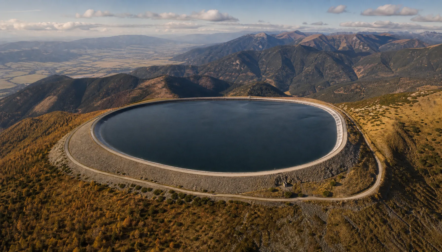
The upper reservoir of the Čierny Váh pumped-storage plant on its ridgeHorná nádrž prečerpávacej elektrárne Čierny Váh na hrebeni
Two headwaters and a staircaseDva pramenné toky a schodisko
The Váh has two sources and takes its name only where they meet: the Biely Váh comes down from the High Tatras, the Čierny Váh out of the Low Tatras, and they join at Kráľova Lehota. From there the river runs west through Liptov, turns north-west at Ružomberok, breaks through between the Malá Fatra and the Strážovské vrchy and follows Považie south to the plain, reaching the Danube at Komárno.Váh má dva pramenné toky a meno dostáva až tam, kde sa stretnú: Biely Váh prichádza z Vysokých Tatier, Čierny Váh z Nízkych Tatier a spájajú sa pri Kráľovej Lehote. Odtiaľ tečie rieka na západ cez Liptov, pri Ružomberku sa stáča na severozápad, prediera sa medzi Malou Fatrou a Strážovskými vrchmi a Považím smeruje na juh do roviny, kým sa pri Komárne nevleje do Dunaja.
Almost none of that is a free river any more. From Liptov downwards the Váh runs as a cascade: a barrage, then a lined canal carrying the water to a power station, then back into the bed, then the next step. The natural channel keeps a residual flow and the canal takes the rest, which is why so many stretches of the Váh appear on a map as two parallel rivers, one straight and one meandering.Voľnou riekou už z toho nie je takmer nič. Od Liptova nadol tečie Váh ako kaskáda: hať, potom opevnený kanál, ktorý vodu privádza k elektrárni, potom späť do koryta a hneď ďalší stupeň. Prirodzené koryto si drží zostatkový prietok, kanál berie zvyšok — a preto sa mnohé úseky Váhu javia na mape ako dve rovnobežné rieky, jedna priama a druhá meandrujúca.
The scheme was begun before the Second World War, built out through the 1950s and 1960s and completed at the top with Liptovská Mara in the 1970s. Flood control was the first argument for it, power and — on the lower river — irrigation the others. Together the steps make the largest source of hydroelectricity in the country after the Danube.Sústava sa začala budovať ešte pred druhou svetovou vojnou, rozvinula sa v päťdesiatych a šesťdesiatych rokoch a na hornom konci ju v sedemdesiatych rokoch uzavrela Liptovská Mara. Prvým argumentom bola ochrana pred povodňami, ďalšími elektrina a na dolnom toku zavlažovanie. Spolu sú tieto stupne po Dunaji najväčším zdrojom vodnej energie v krajine.
What Liptovská Mara coveredČo zaliala Liptovská Mara
Liptovská Mara holds more water than any other reservoir in Slovakia and stands at the head of the whole cascade, which is precisely its job: it stores the spring melt and releases it through the summer so that every step below has something to work with. Immediately downstream a smaller basin at Bešeňová evens out the surges the power station makes.Liptovská Mara zadrží viac vody než ktorákoľvek iná nádrž na Slovensku a stojí na čele celej kaskády — a presne to je jej úloha: uchová jarné topenie a cez leto ho vypúšťa tak, aby mal každý stupeň pod ňou s čím pracovať. Výkyvy, ktoré elektráreň spôsobuje, vyrovnáva hneď pod ňou menšia nádrž pri Bešeňovej.
Filling it took the floor of the Liptov basin. More than a dozen villages were emptied and demolished, among them Liptovská Mara itself, which gave the lake its name and had stood there since the Middle Ages; Liptovská Sielnica was rebuilt from scratch on higher ground. What could be moved was moved — the early Gothic manor house from Parížovce and the church from Liptovská Mara were taken apart and re-erected at the open-air museum of the Liptov village at Pribylina, which exists largely because the valley was flooded.Naplnenie nádrže si vyžiadalo dno Liptovskej kotliny. Vysťahovali a zbúrali vyše desať obcí, medzi nimi aj samotnú Liptovskú Maru, ktorá dala jazeru meno a stála tam od stredoveku; Liptovskú Sielnicu postavili nanovo vyššie nad hladinou. Čo sa dalo preniesť, prenieslo sa — ranogotický kaštieľ z Parížoviec a kostol z Liptovskej Mary rozobrali a znovu postavili v Múzeu liptovskej dediny v Pribyline, ktoré vzniklo do veľkej miery práve preto, že dolinu zaliala voda.
The lake is now the centre of the Liptov summer: sailing from Liptovský Trnovec, a marina, warm shallows at the eastern end. In a dry year the level drops visibly by late summer and the shoreline moves. The whole northern horizon is the Tatras, which is why almost every photograph of the reservoir is taken looking that way.Dnes je jazero stredobodom liptovského leta: jachting z Liptovského Trnovca, prístav, teplé plytčiny na východnom konci. V suchom roku hladina do konca leta viditeľne klesne a breh sa posunie. Celý severný obzor tvoria Tatry, a preto takmer každá fotografia priehrady vzniká práve týmto smerom.
The battery on the Čierny VáhBatéria na Čiernom Váhu
High above the Čierny Váh valley, on a shoulder of the Low Tatras, sits an artificial basin with no river flowing into it: the upper reservoir of the country's largest pumped-storage plant. At night, when demand falls and the nuclear stations cannot be turned down, their surplus output pumps water up from a lower reservoir in the valley; at peak hours it runs back down through the turbines and the plant becomes a generator.Vysoko nad dolinou Čierneho Váhu, na rázsoche Nízkych Tatier, leží umelá nádrž, do ktorej nepriteká žiadna rieka — horná nádrž najväčšej prečerpávacej vodnej elektrárne v krajine. V noci, keď spotreba klesne a jadrové elektrárne sa nedajú stiahnuť, ich prebytočný výkon prečerpá vodu z dolnej nádrže v doline nahor; v špičke tá istá voda steká cez turbíny späť a elektráreň začne vyrábať.
It is the least visible and one of the most useful parts of the Slovak grid — a battery made of rock and water, able to go from standstill to full output in minutes, which is what keeps the system stable when a large unit trips. The road up to the rim carries walkers and cyclists for the view over Liptov, but the works themselves are an operating industrial site with the access rules that go with it.Je to najmenej viditeľná a zároveň jedna z najužitočnejších častí slovenskej sústavy — batéria z kameňa a vody, ktorá sa z pokoja dostane na plný výkon za pár minút, a práve to drží sústavu stabilnú, keď vypadne veľký blok. Cestu k hornej nádrži využívajú turisti a cyklisti pre výhľad na Liptov, samotné dielo je však prevádzkovaným priemyselným areálom so zodpovedajúcimi pravidlami vstupu.
Downstream: Sĺňava and the lowlandDolu prúdom: Sĺňava a nížina
Below Považie the river slows and the steps get shallower. Sĺňava, built on the Váh at Piešťany in the 1960s, is the best known of them: about four hundred and eighty hectares of water at the edge of the spa town, used for rowing and paddling and walked or cycled right round on the dyke.Pod Považím sa rieka spomaľuje a stupne sú nižšie. Najznámejším z nich je Sĺňava, postavená na Váhu pri Piešťanoch v šesťdesiatych rokoch: asi štyristoosemdesiat hektárov vody na okraji kúpeľného mesta, kde sa vesluje a pádluje a ktorú možno po hrádzi obísť pešo alebo objazdiť na bicykli.
It is also a bird reserve, protected since 1980, and the gravel island in the middle is a nesting ground above all for common terns and black-headed gulls. A racing course, a promenade and a breeding colony on one sheet of water is a fair description of what the whole cascade has become: infrastructure used for everything except the reason it was built.Zároveň je to vtáčia rezervácia chránená od roku 1980 a štrková ostrovná plocha uprostred je hniezdiskom najmä rybára riečneho a čajky smejivej. Pretekárska dráha, promenáda a hniezdna kolónia na jednej vodnej ploche celkom presne vystihujú, čím sa stala celá kaskáda: infraštruktúrou, ktorú ľudia využívajú na všetko okrem toho, na čo vznikla.
The last large step, Kráľová, lies out on the Danubian Lowland, and below it the Váh finishes as a regulated channel between dykes. A long-distance cycle route follows the crest of those dykes in stretches and is still being joined up; where it exists it is the simplest way to see the system whole — flat riding with a barrage every hour or so.Posledný veľký stupeň, Kráľová, leží už na Podunajskej nížine a pod ním končí Váh ako regulované koryto medzi hrádzami. Po korune týchto hrádzí vedie po úsekoch diaľková cyklotrasa, ktorá sa stále dopája; tam, kde existuje, je najjednoduchším spôsobom, ako vidieť sústavu vcelku — rovinatá jazda a zhruba každú hodinu jeden vodný stupeň.